International Conference on GNSS for the Development of Sub-Saharan African Countries – Call for abstract
Posted on: March 28, 2013
The main objectives of this International Conference are to foster and promote African technological and scientific competences that have a clear potential for Galileo and EGNOS products and services/applications.
More particularly, the conference aims to:
- foster the development of innovative ideas and new products related to the space sector;
- promote the collaboration between African industrial and university students to obtain a more stable and better structured African satellite landscape;
- better position the local industry with regard to future African and worldwide activities so as to be ready to submit competitive bids when the respective calls are published;
- increase the technological maturity of ideas developed by academia and to promote competitive Space products thanks to partnerships with industry.
Within this International Conference, AiA consortium launches the Best African Student Paper Award 2013. The Award is assigned on the basis of the quality of the written abstract and the oral or poster presentation. All papers are review by a scientific international committee. To be considered for the Award, the abstract must be identified as a student’s paper at the time of submission. The award is open to African students.
In this frame, a call for abstract has been issued for the “Best African Student Paper Award 2013”. The Award is assigned on the basis of the quality of the written abstract and the oral or poster presentation. All papers are review by a scientific international committee. To be considered for the Award, the abstract must be identified as a student’s paper at the time of submission. The award is open to African students.
The conference is planed the 30th-31st of May 2013 at Hotel TEROUBI, Boulevard Martin Luther King BP 1179 Dakar – SENEGAL
Further information is available on AIA website.
Awareness In Africa – Libreville (Gabon) Workshop – 2/3 November 2012
Posted on: March 18, 2013
The AiA project, organised the first Colloque for the promotion of GNSS/Galileo for the development of the sub-Saharan Africa in Libreville (Gabon). Around 50 people from Gabon and Cameroon attended the Colloque, among them:
- Government of the Gabonese Republic: Dr Pierre Moukeli, New Technologies Advisor of the President Bongo – Mr Alex Bernard Bongo Odima, President of the National Agency for digital infrastructures and frequencies,
- European Union delegate in Gabon, in Sao Tomé and Principe and in Equatorial Guinea: M. Jean-Eric HOLZAPFEL,
- Universities: Prof. Dr. Pierre Nzinzi, rector of the Omar Bongo University of Libreville – Several universities teachers and researchers,
- European delegates of the EC and the GSA: Bruno Roussel (SUCCESS project) and Simon Chambers (AXYSNAV),
- Scientific community and industry: representative of the Agency for Space Studies and Earth Observation, Companies specialised in topography, hydrography, and IT systems.
- Students at IAI (2 presentations of R&D projects).
This workshop was the opportunity to exchange information and point of views for the use and benefits of GNSS and Galileo for Africa. African people were very interested to have technical information on GNSS and on GNSS programs as many questions rose on these subjects. EC and GSA representatives provided valuable information and views, answering to multiple questions from the attendance.
During the Workshop, many companies and administrations indicated their interest to develop or support GNSS applications for the mass market and for scientific purposes. Nevertheless, the participants raised the fact that the lack of digital maps in Africa is an obstacle to develop some interesting GNSS applications. On the other hand, Earth Observation combined with GNSS applications were seen by participants as powerful enablers for land management applications.
Finally, this workshop raised a high interest to set up GNSS masters in universities and IAI. The scientific background is of very good quality and such initiative would for sure support the development of adapted GNSS applications to Africa specificities and needs. In that context, the teachers and researchers request European help to assist them.
In complement to educational matters, works, results, solutions and/or developments in Africa are lacking budgets to have them presented in international conferences. Thus travel budgets were asked to make the international GNSS community to fully take advantage of African efforts towards GNSS applications development in Africa.
SATSA training sessions completed
Posted on: February 08, 2013
The second SATSA training session covered the engineering & programmatic aspects of a SBAS, from the feasibility analysis and mission definition to the operational phase. Besides the development and implementation of a SBAS, a particular focus was placed on applications most relevant to South Africa. Dr. Nestor Zarraoa and Javier Ostolaza, both from GMV, lead this session and allocated significant time for hands-on training using GMV’s engineering tools (magicSBAS, eclayr, and magicGemini).
This training session was held in August (23rd-26th), at the ATNS Aviation Training Academy at the O.R. Tambo International Airport and was attended by ATNS, CAA, industry consultants and SANSA. magicSBAS, GMV’s SBAS testbed, was installed at the SANSA Space Operations premises at Hartebeeshoek using data from South Africa’s existing network of GNSS stations (TrigNet) in order to provide an EGNOS-like signal – which could then be accessed via the Internet. eclayr and magicGEMINI software helps to determine the performance of the magicSBAS EGNOS-like signal generated, and will prove indispensible for the SATSA trials in early 2013.
The third SATSA training session was held at the ATNS Engineering and Technical Services, Cape Town, South Africa from 10 to 14 September 2012. The presenters for the this course were Luis Javier Álvarez Antón and Amaya Atencia Yepez from GMV. This training had a focused on two areas, firstly the use of GNSS in Aviation and all its aspect stretching from ICAO strategy to regulatory requirements also covering the technical details for the system and finally procedure development.
The second main topic focused on safety engineering and its application in the aviation domain when looking at the implementation of GNSS technologies. The training was illustrated with hands-on exercises that ranged from SBAS procedure design using software tools, to participatory exercises in safety engineering. What kept the attendees on their toes was the daily safety quiz used to review learning up to that point. The third course saw participation from SANSA, ATNS and a large delegation from CAA, which was particularly encouraging considering the topics covered.
The last SATSA training session was held on 13-14 November 2012 at the ESSP Operations Centre at AENA near Madrid, focusing on operations, maintenance and service provision. This training workshop was organised by GMV and included training lectures from ESSP staff. The training addressed topics such as EGNOS services, performance, roadmap NOTAM and the LPV implementation status in Europe, as well as training, quality safety and security management. Trainees, from SANSA, ATNS and the South African Civil Aviation Authority (CAA), had the opportunity to visit both ESSP and AENA installations such as the ASQF, NOTAM and EDAS services and also the EGNOS MCC and NLES equipment room.
 |
 |
| A visit to the ESSP Operations Centre at AENA near Madrid | Attendees of the second SATSA Training session at ATA, Guateng, South Africa |
A pre-operational demonstrator for a Space Based Augmentation System adapted to the South African region has been setup
Posted on: February 08, 2013
In the scope of the GSA FP7 project “SBAS Awareness and Capacity Building for South Africa” (http://www.satsa-project.eu) a pre-operational demonstrator for a Space Based Augmentation System (SBAS) adapted to the South African region has been setup. This demonstrator, which disseminates a real augmentation signal over Internet, is being used and operated by the South African Space Agency (SANSA) with two main objectives. On the one hand, it is used as a key training tool in the SBAS capacity building program included in the project. On the other hand, the SBAS demonstrator will be used during several training trials that be conducted, in collaboration with several GNSS user communities in South Africa, to show the services and performances that SBAS technology can bring to South Africa, not only for Civil Aviation but also for other applications requiring improved accuracy. The project coordinator company, GMV, installed the SBAS pre-operational prototype based on its tool magicSBAS (http://www.gmv.com/en/space/magicSBAS/index.html). Two different physical instances of the demonstrator are executing in real time: one in GMV premises in Madrid (backup instance) and the master processing center operated in SANSA Space Operation Centre in Hartebeesthoek.
The demonstrator is configured to collect GPS real-time data (observation measurements and ephemeris) from a regional network of reference stations. In South Africa, the regional network operated by TrigNet collects data from over 60 reference stations that are distributed using the NTRIP protocol. magicSBAS collects data from around 20 of those stations and computes satellite orbits and clocks, ionospheric and integrity information in order to generate the GPS SBAS correction messages (according to RTCA DO-229D) to be distributed to the final user via internet using the ESA SISNeT protocol. However, as some commercial receivers do not include SISNeT capabilities, magicSBAS also disseminates the SBAS messages emulating Virtual Reference Stations through NTRIP protocol using RTCM 2.3 format.
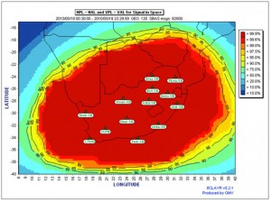
The real-time SBAS performances can be consulted on-line (magicgnss.gmv.com/rsa). On this web-based demonstrator, upon selection of a particular station, the right-upper quadrant shows the SBAS real-time performances for that specific receiver – displaying the evolution of the horizontal and vertical errors and protection levels which are updated every 10 seconds. Note that those position errors are computed by magicSBAS when applying the SBAS corrections to the input data and checking the position obtained against the known true position of the station defined by configuration. In the lower section of the website the real-time user level performances of the SBAS messages generated by magicSBAS are analysed by the magicGEMINI tool.
magicGEMINI receives on one side observation and navigation measurements from any configured station using the NTRIP protocol, and the SBAS message from any SISNeT server on the other. It not only computes the performance at user level for the specific location (errors, protection levels, levels of confidence) but also extrapolates the protection levels over the service area configured. Those plots are uploaded every 30 seconds to the website (in order to reduce internet bandwidth) giving an idea of the real-time performance over the South African area. It is emphasized that the SBAS signal can be acquired by interested users inside of the service area with an appropriate internet connection. Interested users are encouraged to contact the project for further information and support at satsa@gmv.com.
First seminar on GNSS promotion for the development of countries in Sub-Saharan Africa
Posted on: October 11, 2012

This seminar is the first of several regional seminars organised by AIA project consortium with the support of the European Commission. The aim is to vulgarise scientific and technological aspects of GNSS and their applications.
GNSS are considered as essential tools for the economical and social development of developing countries as they can benefit directly to numerous and fundamental applications related to the agriculture, transport means, environmental management…
This seminar will help participants to understand concretely what the added values of GNSS are to support countries’ development with respect to environmental constraints and to struggle against poverty.
Scientifics, experts and industrials from Europe and Africa will meet to discuss of the new opportunities which are enabled by the GNSS. This will be the opportunity for African responsible to discover the numerous benefits of GNSS use. This seminar is the opportunity to create users’ networks among private companies and administrations or institutions.
Objectives:
- To demonstrate the GNSS benefits to African stakeholders responsible for the development of their region or country
- To support and encourage public and private partnership and to promote the cooperation between Sub-Saharan Africa and Europe
- To define concrete actions of partnerships to make African stakeholders benefits from GNSS use
- To increase the number of GNSS applications’ users
It is scheduled for the 2-3 of November 2012 at Institut Africain d’Informatique (IAI) in Libreville, Gabon
For subscriptions, please contact seminar organisers on these addresses:
Email : secretariat@acsal-science.org and obalira@iai-siege.com
More information is available here: http://www.gnss4africa.lu