Perspectives in non-aviation sectors for an EGNOS-like service in Africa
If the primary objective of EGNOS is to fulfil the requirements of the aviation sector, then other economic sectors can also benefit from the high quality of this service in terms of availability, continuity and reliability.
The numerous studies and the development of applications carried out in Europe with EGNOS give a new light on these possibilities.
On 2nd March 2011 EGNOS Safety of Life Service was officially put at the disposal of civil aviation in Europe. Since that date EGNOS Open Service has made remarkable progress in terms of accuracy corrections, timing and protection limits. This article summarises the lessons learned from Europe and identifies the benefits of such applications for Africa.
Reminder: key benefits of SBAS in Africa for the non-aviation sector
The corrections data provided in real time by EGNOS service terrestrial segment allow reaching a submetric geolocation accuracy all over a vast area (without additional terrestrial segment). These corrections, directly accessible from the SBAS satellites on a GPS like standard, can be processed by a cheap receiver. The benefit of this submetric accuracy provided for free with a certain level of liability can support mapping and surveying works in numerous sectors.
Mass-market receivers compatible with SBAS will use a service which will be carefully controlled by national civil aviation authorities in each country of the region. It will therefore ensure full trust regarding non-aviation sectors users.
The mitigation of scintillation effect which can severely damage the quality of positioning in subtropical countries is another positive feature for Africa.
EGNOS can therefore support activities such as the determination of areas and perimeters, inventory and control of assets and management of natural environments.
Agriculture sector:

It is worth mentioning the agricultural applications of EGNOS whose EDAS DGPS corrections (EDAS is an EGNOS data service broadcast on Internet) contribute to keep the pass-to pass accuracies in the range of 10-20cm, while up to a distance of approximately 250 km from the target EGNOS station. This remark must be taken into account for the choice of EGNOS Ranging and Integrity Monitoring Stations locations in Africa.
EDAS will improve the efficiency of their operations with a free-of-charge correction service. We consider the EDAS DGPS corrections can be a very attractive alternative for many users with no need for centimetre level accuracies and reluctant to pay for a subscription.
Maritime and inland waterways:

The use of SBAS corrections for navigation, in both coastal waters and inland waterways, has already caught the attention of many European authorities, which are interested in its potential to complement or replace their DGPS radio beacon networks. Some ongoing projects supported by the European Gnss Agency (GSA) demonstrate the operational performance of the transmission of EGNOS corrections converted to Differential GPS corrections over the existing transmission infrastructure (AIS or VDES base stations/IALA beacons).
SHOM (The French Hydrographic Office) in charge of developing nautical charts in the French maritime boundaries is using EGNOS to correct errors in the position. It’s worth mentioning that the position of the vessel is one of the major sources of the sounding position error budget. Horizontal and vertical uncertainties of the soundings are specified by international standards. EGNOS is used both close and far to the shore.
Construction and Public Works:
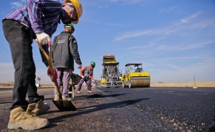
Satellite positioning is already widely used by public works companies. It simplifies the precise layout of the structures and allows real-time monitoring and measurement of daily quantities. For example, it can facilitate the verification of the number of passes of the compactor. The use of an SBAS receiver could avoid settling a Real Time Kinematic reference station. Construction surveyors’ daily job could be facilitated by simplifying the daily statement of work carried out and expenses incurred.
Maintenance of linear transport infrastructures:
With GNSS receivers already on the market and which, tomorrow, will be increasingly associated with a mobile phone, it is possible to position within a meter all the objects that make up a road or rail infrastructure and this in a universal repository such as the International Terrestrial Reference Frame (ITRF) .
At a time when the number of intervention on the public road and rail domain is growing due to aging of infrastructures, it would be highly desirable to invite the building owners to systematically use this mode of positioning. Satellite positioning is a powerful tool that will help homogenize the different transport information systems. Moreover, with the automatic reassembly of geo-localized information, considerable productivity gains are possible for the agents called upon to intervene daily on this heritage (maintenance work reports, patching plans, road information, and national statistics on accidents …).
The systematic recording of the position and time associated with automatic data processing brings a quality of information that cannot be obtained with traditional paper surveys. Verification of existing mapping databases is the first step. A cheap receiver makes it possible to highlight deviations, to correct errors and especially to complete the design of networks. Inconsistencies are sometimes surprising. The second step is to recreate a base that is fully compatible with GNSS measurement results, but with greater accuracy.
Perspectives: Open street map in Africa
GNSS provides a universal repository that is easily accessible anywhere in the world, which is essential for developing advanced geographic information systems and performing wealth management.
Several major cities in France are already working on setting up this type of data bank. Instant access to a precision of one centimeter thanks to the diffusion of the differential corrections made from a permanent GPS Network of the National Geographic Institute, allows managers of urban roads to build accurate databases, digitized, which reconcile the parcel of the public domain and the cadastral data. These bases, once enriched by overhead or underground networks, a digital model of terrain and elevation, are irreplaceable tools for better management of urban heritage and the implementation of ambitious public transport and urban planning policies.
With a team of about twenty students in geography, thanks to the supervision of a university or training center, the Open street Map tools enriched with an SBAS service could generate a geographical database accessible to all, covering the whole smart city themes : infrastructures, urban planning, aquatic environments, networks, streets and roads sewages, etc.
Currently EGNOS augments GPS using the L1 Coarse/ Acquisition (C/A) civilian signal function by broadcasting correction data and integrity information for positioning and navigation applications over Europe. The next generation of EGNOS, EGNOS V3, will augment GPS and Galileo constellations in the L1/E1 and L5/E5a bands and will improve the accuracy and reliability of the positioning, navigation and timing information over Europe.
SBAS services in Africa can contribute to increase the use of GNSS and to prepare the coming up of High Accuracy services provided by Galileo soon. Widely available free accuracy will benefit real-time mapping solutions everywhere for everybody.

Roger Pagny graduated from the National Civil Engineering School (Ecole Nationale des Ingénieurs des Travaux Publics) in 1973 and obtained a post-graduate degree in economics at the Political Science Institute in Paris in 1981. After extended stays in Africa and the Asia-Pacific zone, Roger Pagny joined the Traffic and Road Safety Department in 1995 to take charge of French participation in European ITS projects. In 2002, he was appointed to highlight the interests of the Ministry within the steering bodies of the European satellite navigation programs EGNOS and GALILEO.
As head of the satellite applications office, he was project manager for the Ministry’s satellite applications plan, member of the Galileo Compatibility Signals Interoperability working group and a member of the Galileo Commercial working group. He is now vice president of ATEC-ITS France, a non profit association in charge of promoting innovation among the transport sector.